In this blog, linked to their recently published Open Access article (online first, February 2026) in Environment and History, ‘Multifunctional Landscapes in Central Mainland Portugal: The Royal Administration of Almeirim and Sustainable Land Use from the Fourteenth to the Sixteenth Century’, Koldo Trapaga-Monchet and Raúl Romero-Calcerrada aim to shed light on the history of the royal forests of Almeirim (current municipality of Almeirim) in a longue durée perspective through a multidisciplinary approach.
Almeirim is a city of around 22,500 inhabitants that covers 222 square kilometres and is located on the left margin of Tagus River. Almeirim belonged to a larger historical, cultural and geographical area called Ribatejo, which encompasses both margins of the Tagus River. From the medieval period and throughout the Early Modern period, the history of Almeirim is linked to the royal family who constructed a palace there (Paço Real de Almeirim). A noteworthy 3D reconstruction of this history and the main landmarks of the royal family and noble families can be found at: https://www.youtube.com/watch?v=dvn-NV9-iT0
Although local scholars have brilliantly reconstructed the history and evolution of Almeirim, there are some gaps in our current knowledge of the royal forests of Almeirim, particularly regarding the landscape perspective, which our article addresses. When referring to ‘landscape’, it is essential to distinguish between two complementary meanings. On the one hand, the perceptual landscape is the landscape as it is seen, imagined and culturally interpreted, a visual and symbolic construct shaped by the observers of each period. On the other hand, the landscape as a system refers to the material, ecological and socio-economic structures that organise a territory: its land uses, resources, infrastructures and the interactions between human communities and their environment over time. In the case of Almeirim, both dimensions overlap: while the perceptual landscape reflects how contemporaries understood and represented the territory, the systemic landscape reveals the long-term practices, regulations and ecological dynamics that enabled multifunctional land use.
Based on extensive historical and cartographic sources, our study offers a fresh perspective on the history of Almeirim for the following reasons.
Firstly, the combination of methods and sources of history, geography, cartography and digital cartography has provided new light on the continuities, changes and adaptations in land cover and land use of the royal forests of Almeirim in a long-time perspective spanning from the early fourteenth to late sixteenth centuries. Secondly, we have created new maps on restrictions and land-uses of Almeirim to create a narrative of a geographically integrated history. The maps were produced with varying levels of accuracy depending on the available cartographic and historical sources. In some cases detailed historical maps were available, such as Maps 1 (Geographical map of the hunting grounds of Santarém (1775) and 2 (The royal forests of Almeirim) in the article. With these and historical sources, it was possible to identify original boundaries and place names. These elements were georeferenced and reinterpreted in relation to current cartography, using roads, waterways, topographic features and place names as references. Thanks to this process, the historical boundaries could be reproduced with relative accuracy, as shown, for example, in Figure 1 below (Figure 4 in the article).
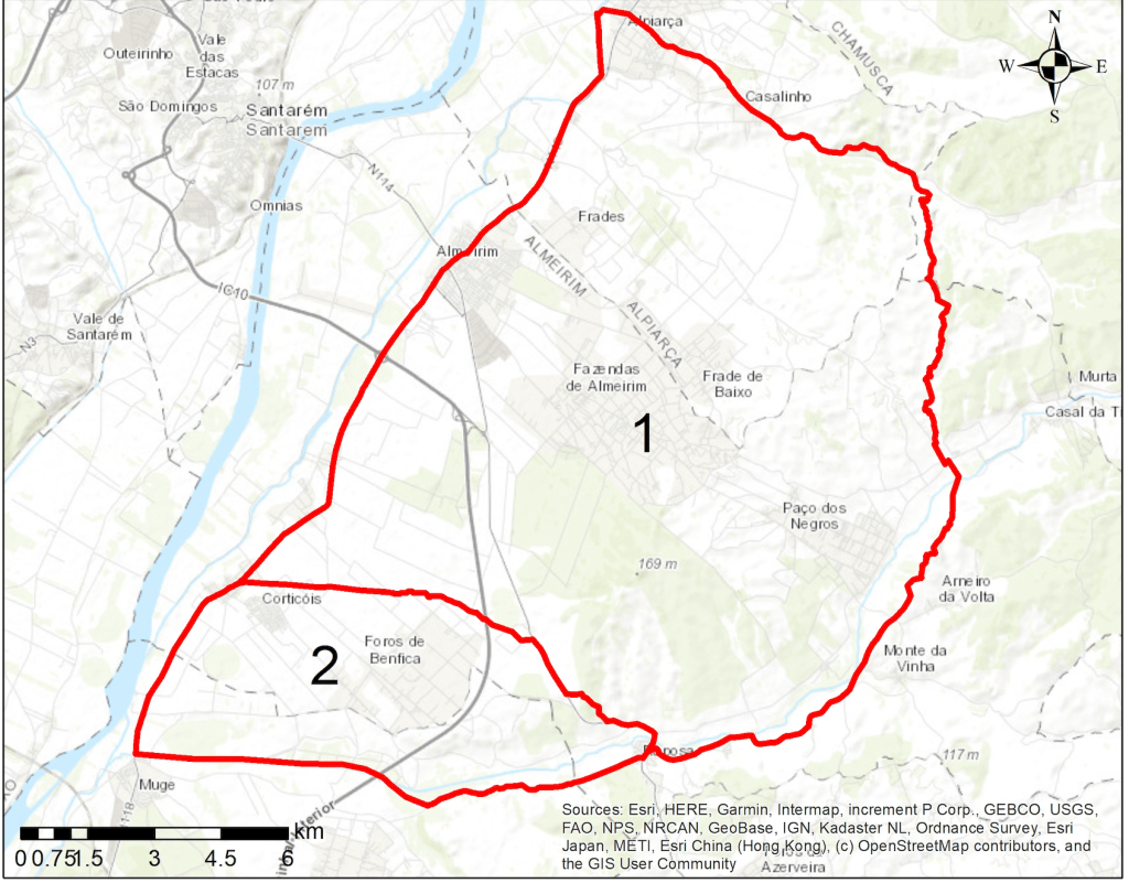
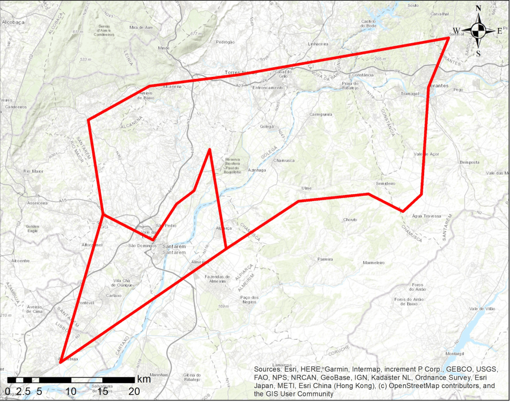
This figure represents the limits of the old and new royal forests. In other cases, when only textual references or place names were available, as in Figure 2 (Figure 2 in the article), approximate polygons were generated from the locations identified in the sources. This figure represents the area entrusted to the monteiro-mor of Santarém in 1407.
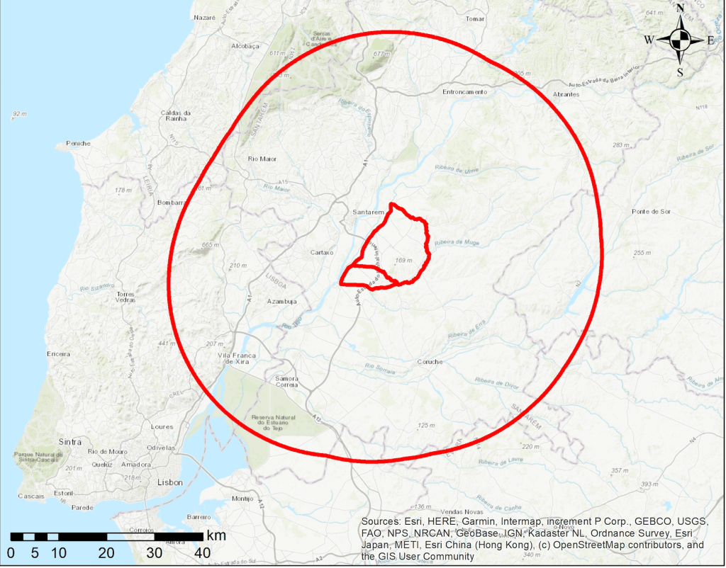
Besides, when the descriptions included specific distances, spatial analysis tools, such as buffering, were used, as in Figure 3 (Figure 7 in the article), in which the prohibitions on bringing animals and rifles are delimited, as detailed in 1565 (Source: BA, Ms. 44-XIII-61, fol. 84r–v).
This mapping not only provides new insights about the history of Almeirim within a larger territorial area, but also proves the sound knowledge that the Royal Administration had of the territory. The legislation was constructed on the basis of the space and natural resources available there.
Secondly, the combination of approaches from other authors whom we quote throughout text has permitted us to show that: 1) the royal forests of Almeirim were multifunctional landscapes co-created between the Portuguese Crown and other agents, with the Crown likely acting upon existing socio-ecological realities; 2) this ensured land-use sustainability in line with other human-made Mediterranean landscapes such as the Portuguese montados; 3) the royal forests of Almeirim represent a paramount case ofshared property and co-creation of legislation and administration between the Crown and various stakeholders or agents; 4) the history of Almeirim and its land-uses cannot be understood without taking into consideration the dynamics of the surrounding areas that made up Ribatejo.
Thirdly, far from being static scenery, landscapes are living archives in which centuries of human decisions, negotiations and conflicts are inscribed into the land. In Almeirim, every hill, every wetland, every forest boundary and every land-use practice narrates the long history of co-creation between the Portuguese Crown, local communities and Mediterranean ecosystems. These material traces (hunting areas, ‘montados’, cultivated fields, ‘coutadas’, and communal spaces) reveal how past societies understood, organised and made their environment productive without losing sight of its capacity for regeneration, giving rise to genuinely multifunctional landscapes where agro-silvo-pastoral uses, communal practices and ecological functions coexisting in dynamic balance. Thus, the landscape of Almeirim is not merely a backdrop for the events studied: it is a historical source in its own right, a living testimony to the sustainability, tensions and adaptations that shaped this territory between the fourteenth and sixteenth centuries.
Last but not least, our approach can be replicated to provide further data not just on the environmental geography and history of Almeirim; it is transversal to geography, legal and administrative history. Our methodology can not only be replicated to study the royal forests of Portugal (for instance Benavante, Coruche, Salvaterra de Magos, Santarém) but can likely be replicated in other European scenarios such as the royal sites (‘reales sitios’) of Spain.
Acknowledgments
This blog has benefited from the research project ‘Percepción y materialidad de los sistemas socio-ecológicos en la Península Ibérica (siglos XIV-XVIII)’ (project reference PID referencia proyecto PID2024-155668NA-100) funded by the Ministerio de Ciencia, Innovación y Universidades, the Agencia Estatal de Investigación and the FEDER.
