In today’s blog, Stefan Dorondel (of the Francisc I. Rainer Institute of Anthropology, Bucharest and The Institute for Southeast European Studies of the Romanian Academy) makes the case for greater study of river islands and wetlands by environmental historians, presenting an overview of the islands in the lower Danube explored in more historical detail in his article in Environment and History (online first, June 2018), entitled ‘The Play of Islands: Emerging Borders and Danube Dynamics in Modern Southeast Europe (1830–1900)’.
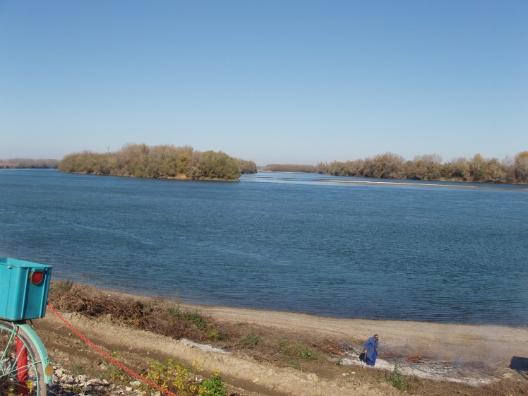
An observer taking a stroll along the Lower Danube would be astonished to see the number of islands scattered along the river. The lush dark-green tropical-seeming vegetation, with what seem to be long and thick creepers tightening the trees, forms a sort of wall which impedes the observer from seeing beyond. Small or larger, roundish or longish, the islands of the Lower Danube – I refer specifically to this part of the Danube in the following – rise mysteriously from the smooth waters of the river (see photo 1 ).

In some parts of the river, for instance next to the Bulgarian city of Belene, several islands form a sort of archipelago (see photos 2 and 3) – an uncanny place for non-riparian people. Islands are fascinating worlds, a hybrid of water, land and vegetation which remind the observer of the biblical separation of the land from waters, as a Romanian writer aptly put it.[1] They grow in those parts of the river where trees, stumps or, in modern times, boat wrecks or even tires form into a sand bar. Steadily, the sand and alluvia brought by the river gather there and a small piece of land rises above the waters. The seeds brought by the river find auspicious conditions to root and grow and, in only a few years, a small island covered by vegetation separates the river into two branches.

Danubian islands have played a crucial economic role for riparian people for centuries. At least from the sixteenth century, the riparian population of Walachia and what today is Bulgaria kept their animals on these islands.[2] Peasants released them in spring and recovered the animals in autumn. Animals were transported with large boats to and from the islands and the owners came once a week to feed the ungulates so they would remember their masters. Otherwise, for about half a year the animals grew in semi-wilderness. It made a lot of sense as long as no resource or labour efforts were required for keeping animals. The rich vegetation of the islands provided nutrition for animals which were naturally confined to a certain area. There were perils as well, for humans and animals as the historical documents attest. For instance, several reports found in local archives show the intervention of the personnel of the Regional Inspectorate for Navigation and Ports of Galaţi city (eastern part of Romania) who saved humans and animals on different islands exposed to devastating floods. One report, dated 25 April 1940, describes how animals and people of several flooded islands were evacuated by using floating bridges carried by tug-boats with no casualties among people or animals.[3] Another document says: ‘On the evening of May 9, [1940] the evacuation of inhabitants, their belongings and their cows from the Stepovici island was accomplished. The operation of boarding and landing of the people suffering from calamity was accomplished under the supervision of the of the navigation and ports employees.’[4] Despite the annual floods, manifested mainly in the spring period, the economic advantages of exploiting the richness of islands outstrip the perils.
This riparian population’s exploitation of islands became more difficult once the nation-state arose in the second part of the nineteenth century, which turned islands into national territory. The military and geopolitical importance of Danubian islands become crucial for the new states which each tried to impose their supremacy in the area. From being a local cornucopia, islands become strategic military points which gave a huge advantage to the owning country: the ownership of such islands eased the construction of bridges to transport the army from one bank to another. This is what happened in the 1877 Romanian and Russian war against the Ottoman Empire, when different islands where used in order to take over the river soldiers, animals and military technique. Yet, the ‘nomadic character of the islands’,[5] moving towards one bank or the other, making and unmaking after a huge flood and changing shape was, and still is, a nightmare for the nation-state. Establishing the thalweg and accordingly the international border along the river was not an easy task nor lacking in political and military disputes. Drawing the thalweg – that imaginary line along the deepest river floor points – depended on islands which constantly moved. This movement put at high risk the diplomatic and military relationship of riparian countries.
Some larger islands were inhabited for centuries as was the case of Ada Kaleh (ada means island in Turkish). When the island was covered by waters in 1971, as an outcome of the construction of the Iron Gates Dam in a joint effort by the Yugoslav and the Romanian governments, the population of around 500 people, mostly Turks, was displaced. The island was a huge tourist attraction as it was the remnant of a bygone cultural world in which the Levant met the Occident. The rich flora and fauna of the island as well as the oriental food acted as a magnet for the Romanian population.[6]
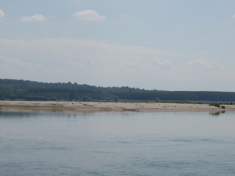
Despite the difficulties posed by the border police of the riparian countries, islands continued to be a prime source of wood, pasture and fish (as some larger islands had ponds and lakes in which the fish remained trapped in the summer – an easy catch for locals) until the instauration of the socialist regime. The practice of husbandry on the islands was so strong in riparian consciousness that in the 1990s, after the dismantling of collective and state farms, people started to send their animals again ‘in the marsh’. That is, onto the islands which are not on the Danube international sector (mainly in the Danube Delta) or, more often, in areas which remained free of levees. Thus, animals grazing in the heat-haze on island pastures or in the marshes next to the Danube’s banks are not an unexpected sight today (see photos 4 and 5).


Regularly, the sows come back with hybrid piglets as the outcome of interbreeding with wild boars. However, most animals are no longer sent onto the islands as many of them are the object of international dispute between riparian countries and thus forbidden to humans.[7] Yet, what was forbidden to humans was not forbidden to animals. The wild boar, a species which thrived before socialism but almost disappeared during socialism (due to systematic hunting and the strict control by state institutions) made a huge comeback and claimed the internationally disputed territories. Now the tropical-seeming vegetation of islands is not only the paradise of birds and insects but also of a continuously rising number of wild boars. Undisturbed by human presence, wildlife thrives in these islands. This does not come without a price for the riparian population as the boars swim during the night from the islands and destroy crops planted in the former floodplain. Or, at least, this is the claim of the riparian population in Romania. Corn is in particular highly prized by the nocturnal intruders. As the insurance companies do not cover incidents involving animals, it is not difficult to understand why in all our interviews with farmers from villages lying along the Danube (Teleorman County, Romania) wild boar appears to be the much hated foe.
The radical transformations of the Danube during socialist times mean no river in the world is more entitled to the brilliant definition by Richard White: an organic machine.[8] Since 1856, after the Crimean War, the Danube suffered innumerable ‘improvements’: its branches were straightened and its waters drained to be easily navigable, it was dammed, its floodplain erased and transformed into agricultural fields. First the European Commission of the Danube, then the socialist states oversaw heavy transformations of the riverscape. These transformations were the token of a modern attitude towards the rivers: they had to be tamed for human sake. Yet, as an interwar Romanian writer who loved the river put it, ‘[the] great river cannot be defeated or tamed. Nature retaliates; the huge floods of the Mississippi river few years ago should be a terrible example’.[9] These transformations had a huge impact on islands as well, as several limnologists have pointed out. Dammed rivers tend to create fewer islands than a ‘free’ river. Yet, somehow the Danube finds the force to create new islands and destroy or erase others. A short anecdote, which merits a longer article, betokens the words of the above cited author. The village of Rast, lying on the Romanian bank of the river, received huge funds (mostly from the EU development budget) in order to build a port. Historically, the entire area was well connected, after 1829 (the Adrianople treaty), with the Danube through small ports. These were the gates towards the world of an agricultural area which started developing at a fast pace, as after 1829 the Walachian Province was free to sell its grains on the global market. During socialism only a few larger ports remained, which were modernised. Rast was not one of them. After the 1990s and especially after the Romanian accession to the EU, a port serving the village was thought to contribute to the economic and social development of the area. Romanian cereals were going to be exported, again, on global markets. The experts foresaw every possible problem by dredging the river, building a high concrete levee and a road to link the village to the river. One thing, though, escaped their calculus. While the port started to be built a small island appeared in the middle of the river (see photo 6).
In few years only the island grew so much that when the port was ready to be opened to ships their access was completely blocked. The island turned the port into a ghost construction and the only beneficiaries of the new infrastructure are several people who anchor their small fishing boats there and local children who wallow in the river waters (see photos 7 and 8). This is a good example of how the hydrodynamics of the Danube screw up the plans of large farm owners, planning people, engineers, policy-makers and international financial institutions.


This text is actually a plea for including river islands – rivers and wetlands more widely – among the research interests of historians and anthropologists. And nowhere is there a more desperate need for this than in Eastern Europe.
Acknowledgments
The field and archival research this text is based on was carried during 2013-2016 was supported by a grant from the Ministry of National Education, CNCS-UEFISCDI, no. PN II-ID-PCE-2012-4-0587. All photographs are made by Stefan Dorondel.
[1] G. Bogza. 2011 [1939]. Ţări de piatră, de foc şi de pământ [Countries of Stone, Fire and Land]. Jurnalul Naţional: Bucureşti.
[2] A. Kayapinar. 2004. ‘Les îlles ottomans du Danube aux XVIe siècle’, in N. Vatin et G. Veinstein (eds), Insularité ottomanes. Istanbul : Maisonneuve & Larose, p. 185.
[3] National Archive of Galaţi, Fund 442, file 62/1940, page 22.
[4] National Archive of Galaţi, Fund 442, file 62/1940, page 30.
[5] K. Lahiri-Dutt and G. Samanta. 2013. Dancing with the River. People and Life on the Chars of South-Asia. New Haven and London: Yale University Press.
[6] See for instance M.B. Bercovici. 2013. ‘Ada-Kaleh şi aromele ei [Ada-Kaleh and Its Aromas]’, in Lucrările atelierului Împărtăşind aceleaşi gusturi: Bucătăria tradiţională comună turcească şi românească [Proceedings of the Workshop Sharing the Same Tastes: The Turkish and Romanian Traditional Cuisine]. Ankara, pp. 37–46. Despite the existence of some books and papers written mainly by Romanian ethnographers, the fascinating history of this island still waits to be told by engaging the environmental historian toolkit.
[7] During socialism these disputes were settled by a mixed commission of technical experts (including limnologists) whose conclusions were adopted by the higher officials and every few decades the thalweg and the border were retraced. These commissions have not met after the 1990s, hence the territorial disputes concerning the newly formed islands and their ownership.
[8] Richard White. 2014. The Organic Machine. The Remaking of the Columbia River. New York: Hill and Wang.
[9] Jean Bart (Eugeniu Botez). 1933. Cartea Dunărei [The Book of the Danube]. Biblioteca Ligei Navale, p. 68.
